Gdzie tkwi przewaga GIS.Box nad innymi systemami GIS?
Systemy GIS to nie samotne wyspy. Możesz mieć najlepszy GIS na świecie, najlepiej wyszkolonych operatorów, ale jeżeli efektem ich pracy jest zestawienie w excelu + setki mapek w PDF to Twoja organizacja traci całą przewagę konkurencyjną, którą zyskuje dzięki świetnemu zespołowi GIS. Firmy, które prowadzą inwestycje na rozległych terenach, analizują tysiące lokalizacji tracą MNÓSTWO czasu, energii i pieniędzy […]
Data.Box – źródło danych dla GIS.Box
🌍 Dane przestrzenne są… ciężkie (działki dla całej Polski to ok 50 GB, BDOT10k kolejne 80 GB… a do sensownych analiz pod OZE w skali kraju trzeba tego więcej). Problemem jest nie tylko samo ich wyświetlenie, ale pobranie, połączenie i utrzymanie w aktualności… To kosztuje mnóstwo czasu… 🎯 Jak usprawnić dostęp do ogromnych zbiorów danych? […]
Pulpit! Nowa możliwość przeglądania danych w GIS.Box
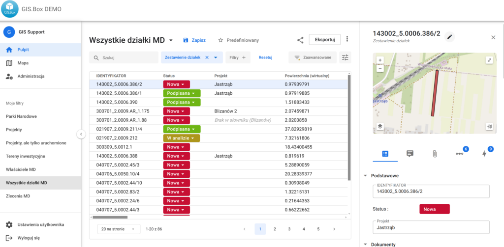
Najnowsza aktualizacja GIS.Box wprowadziła dużą nowość Pulpity, dzięki którym możliwe jest jeszcze wygodniejsze przeglądanie i wyszukiwanie danych. Każdy użytkownik może stworzyć dowolną liczbę Pulpitów na podstawie warstw przechowywanych w Systemie. Pulpity posiadają: Wyszukiwarkę Możliwość filtrowania i sortowania danych Możliwość edytowania danych słownikowych bezpośrednio w tabeli Możliwość zapisania indywidualnych preferencji co do kolejności i widoczności atrybutów. […]
Pobieranie danych BDOT10k we wtyczce GIS Support
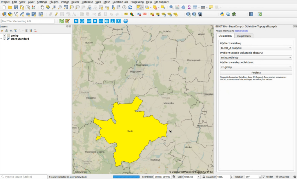
🌍 Korzystanie z BDOT10k* jeszcze nigdy nie było takie proste! Do pobrania jest już najnowsza wersja (2.5) znanej i lubianej Wtyczki GIS Support do QGIS. Najważniejsze zmiany to: ➡️ Narzędzie do pobierania konkretnych warstw z BDOT10k dla wybranych obszarów. Np. Budynków dla wybranej gminy. Zobaczcie filmik. ➡️ Usprawnienia w edycji wieloosobowej danych z GIS. Box. […]
III Spotkanie Użytkowników QGIS 25-26.06.2024 – podsumowanie
Mili Państwo! Emocje po III Spotkaniu Użytkowników QGIS, tak szybko nie opadną… Wczoraj wieczorem obejrzałem na YT wystąpienie Panów Przemysława Aszkowskiego i Marka Krafta na temat wtyczki Deepness i zbierałem szczękę z kolan… Trafiliśmy z formą, w miarę krótkie prezentacje zapewniły odpowiednią dynamikę, brak marketingu na sali plenarnej zapewnił naturalności i nikt nie miał wrażenia […]
Sztuczna inteligencja w GIS.Box – narzędzie automatycznej dygitalizacji WMS
Automatyczna dygitalizacja WMS? Tak! Sztuczna inteligencja ma przynieść przełomy w wielu branżach. W GIS też. Ja jestem dość sceptyczny, szczególnie że wysyp narzędzi wspomaganych AI to po prostu integracje do API różnych czatów. Z tym co widać na filmie, jest jednak inaczej. Narzędzie „Automatyczna dygitalizacja” w GIS. Box to gamechanger. Jak to działa? Wystarczy zaznaczyć […]
III Spotkanie Użytkowników QGIS. Poznań, 25-26.06.2024
Szanowni Państwo! Zapraszamy wszystkich na III Spotkanie Użytkowników QGIS, które odbędzie się w Poznaniu w dniach 25-26.06.2024. Będzie to okazja do poznania się, zaprezentowania swoich rozwiązań w oparciu o QGIS, a także poszerzenia swojej wiedzy na licznych warsztatach. Strona główna wydarzenia dostępna jest pod linkiem: III Spotkanie Użytkowników QGIS GIS Support jest Partnerem Strategicznym wydarzenia. […]
Firmowa baza terenów inwestycyjnych, czyli jedno źródło danych dla wszystkich
Jednym z pierwszych zadań Fabiana (dowiedz się więcej o Fabianie) było wsparcie zespołu Pozyskiwania Inwestora, gdzie pracuje Monika. Zadaniem Moniki jest gromadzenie informacji o bazie terenów pod inwestycje przemysłowe oraz szybkie udzielanie informacji. Prawie codziennie wpada do niej zapytanie pt: „szukamy terenu inwestycyjnego: 20ha, przyłącze energetyczne o mocy X, teren płaski w oddaleniu max 80 […]
Konfigurowalna Wyszukiwarka Obiektów w GIS.Box
Jedną z podstawowych funkcjonalności potrzebnych w dobrym Systemie GIS jest wyszukiwarka obiektów. GIS.Box jest narzędziem, dzięki któremu Specjalista GIS możne w łatwy sposób, bez kodowania, udostępnić dane i narzędzia współpracownikom, więc narzędzi typu wyszukiwarka nigdy za wiele… Do: Szybkiej Wyszukiwarki w Tabeli Atrybutów Filtra Podstawowego Filtra Zaawansowanego, (obydwa mogą być używane jako wyszukiwarki) Wyszukiwarki Adresów […]
Czy GIS się opłaca? To można (i trzeba) policzyć.
Jak co roku w okolicy Świąt, ponownie sięgam po „biblię”, czyli książkę „Rozważania o GIS. Planowanie Systemów Informacji Przestrzennej dla managerów” Rogera Tomlinsona. I jak co roku, odkrywam ją na nowo, bo wraz z wzrostem doświadczenia, pewne aspekty mają inny wydźwięk. Wczoraj „rozważałem” o aspekcie finansowym poszczególnych funkcjonalności. Szczególnie w tym roku uczestniczyłem we wdrożeniach, […]