Location Intelligence (LI) to łączenie danych przestrzennych z danymi biznesowymi i ich analiza w celu odnajdywania wzorców, trendów w celu pozyskania szczegółowej informacji lub głębszego zrozumienia badanego zjawiska. Jest to pojęcie stosunkowo nowe, wywodzące się z bardziej znanego Business Intelligence (BI).
Oprogramowanie BI istnieje na rynku od wielu lat i pomaga analitykom badać dane i szukać odpowiedzi na pytania, które są istotne z punktu widzenia firmy. Oprogramowanie to przeżywa bardzo gwałtowny rozwój w ostatnich latach, które jest spowodowane dwoma czynnikami:
- zwiększonym dostępem do danych gromadzonych w firmach oraz możliwością ich łatwego przetwarzania, spowodowanego cyfryzacją zasobów
- rozwojem chmury i zwiększonym zapotrzebowaniem na interaktywne raporty dostępne przez przeglądarkę, w urządzeniach mobilnych, a nie tylko w profesjonalnym oprogramowaniu
Wiedza o korzyściach związanych z analizami z uwzględnieniem aspektu przestrzennego do analityki w firmach rośnie bardzo szybko. Światy GIS i BI są coraz bliżej, stąd nowe pojęcie: Location Intelligence. Obecnie sytuacja na rynku wygląda dość ciekawie, ponieważ tradycyjni dostawcy oprogramowania GIS próbują zdobyć serca użytkowników oprogramowania BI zaawansowanymi możliwościami analitycznymi, natomiast tradycyjni dostawcy BI, stale rozwijają swoje programy o mapy, dane przestrzenne i proste możliwości analityczne.
Dla kogo jest Location Intelligence?
Dla wszystkich, w pracy których, aspekt przestrzeni jest ważny:
- dla osób analizujących sprzedaż i marketing
- dla osób planujących rozwój (sieci placówek, sprzedaży)
- dla osób optymalizujących procesy logistyczne
Należy wyróżnić dwie grupy odbiorców:
- analityków, którzy na bazie danych (czasem tzw. Big Data) dostarczają produktów informacyjnych (mapy, raporty, zestawienia)
- decydentów, czyli odbiorców tych produktów informacyjnych.
Pierwsi potrzebują danych, narzędzi i metodyk oraz efektywnych narzędzi prezentacji, a drudzy… potrzebują dobrych analityków.
Podstawowe czynności analityczne wykorzystywane w Location Intelligence
Każda firma i branża jest inna i tworzy swoje sposoby analizy (co często prowadzi do budowy przewagi konkurencyjnej), jednak część analiz jest wspólna.
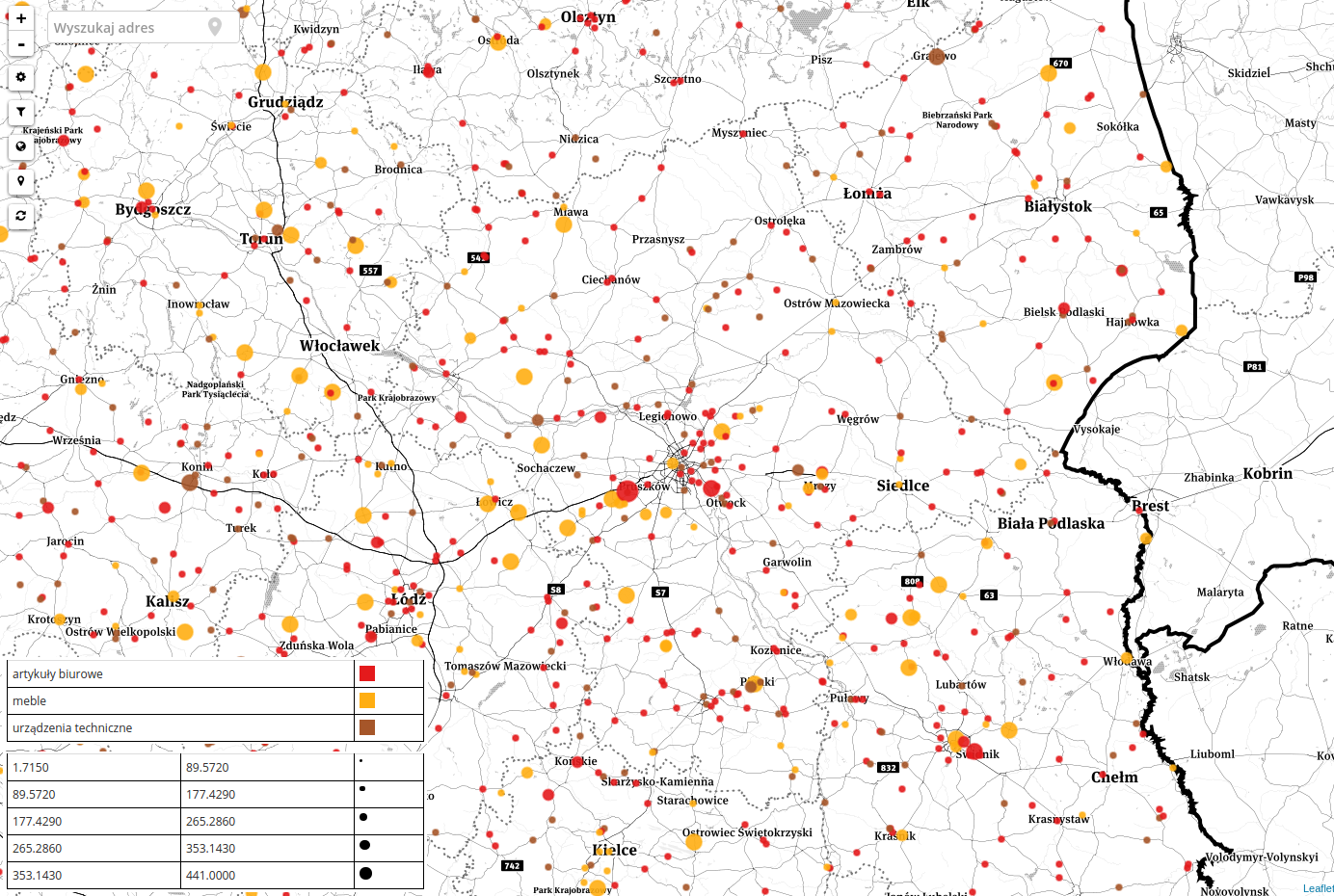
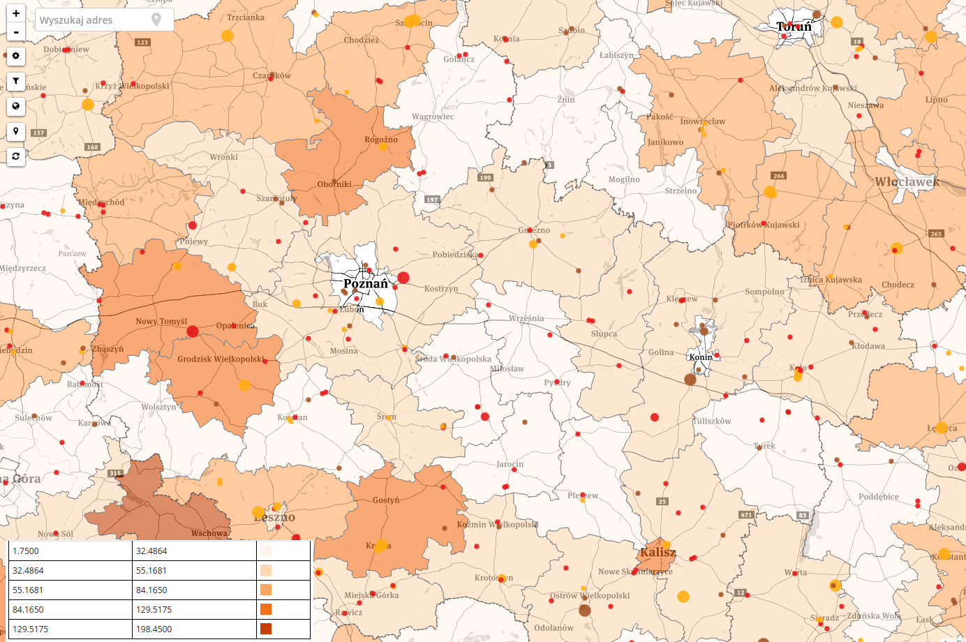
1. Wizualizacja klientów na mapie oraz poszukiwanie wzorców i zależności. Zestawienie 10 tys. adresów w arkuszu kalkulacyjnym nic nie powie. Dodanie wykresu przedstawiającego rozkład w województwach, nadal nie będzie niosło wartości dodanej. Przedstawienie klientów jako punktów na mapie i uzależnienie koloru punktów np. od kategorii klienta, a wielkości od wielkości sprzedaży jest już dużym wsparciem. Na podstawie tego produktu informacyjnego można wnioskować o: maksymalnym zasięgu naszej działalności, występowaniu naturalnych przeszkód w dotarciu do placówki (przejazdy kolejowe, mosty), niskiej lub wysokiej sprzedaży w konkretnych punktach (hotspot i whitespot).
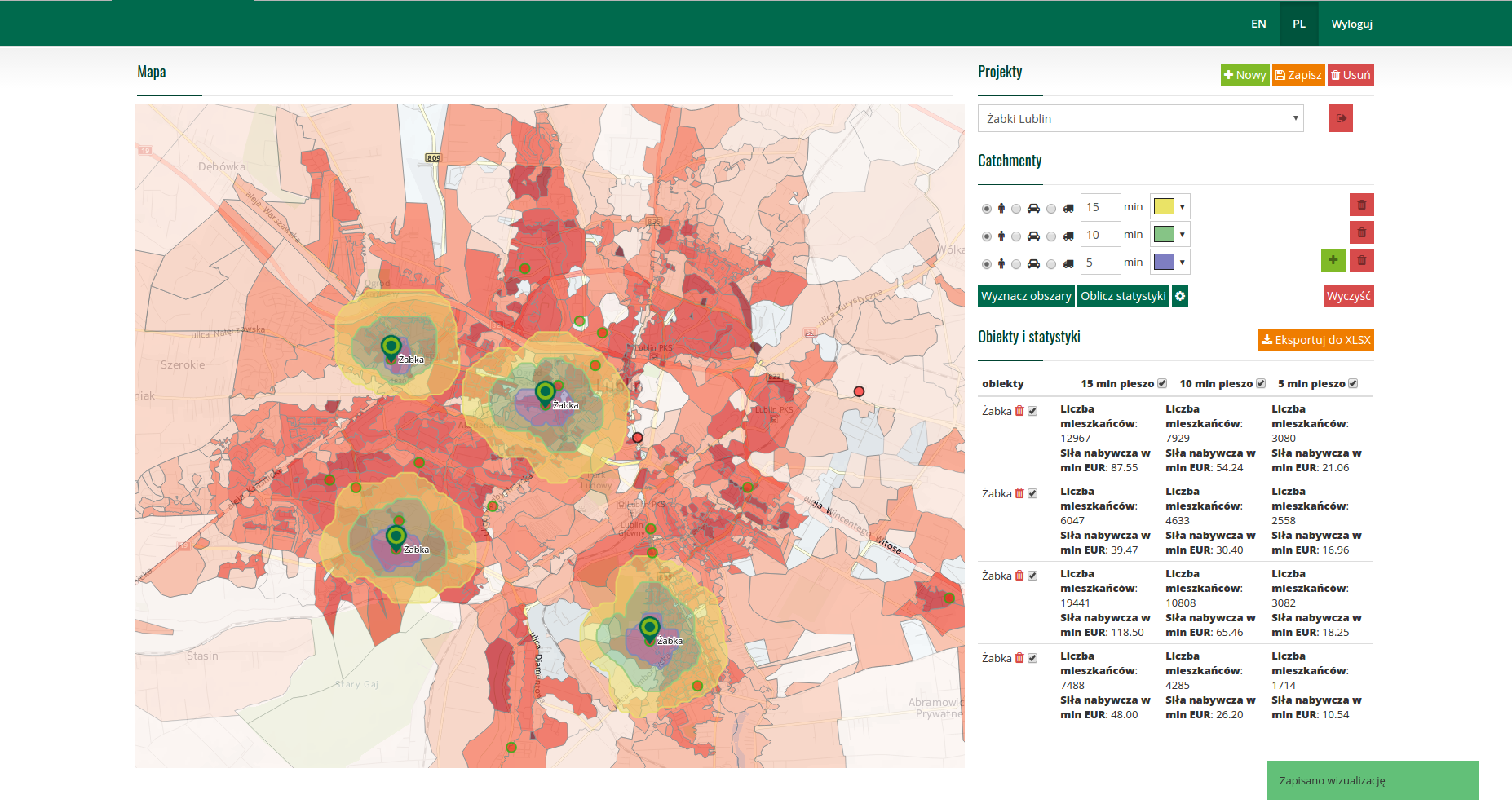
2. Wnioskowanie na podstawie danych statystycznych. Wnioskowanie nt. rozmieszczenia klientów wraz z danymi statystycznymi w postaci kartogramu pozwala nie tylko na analizę wizualną, ale na obliczanie wskaźników i odpowiedzi na pytania: Jaki jest stosunek wartości naszej sprzedaży do przychodów lub liczby mieszkańców w danej okolicy? Czy wszystkie placówki mają podobny potencjał klientów w zasięgu np. 30 min dojazdu samochodem?
3. Analizy przestrzenne. Przykład: Mamy bazę danych potencjalnych klientów w arkuszu kalkulacyjnym. Wiemy, że w środę jedzie transport z Warszawy do Terespola. Ciężarówka jest wypełniona do połowy. Jest to okazja do zaoferowania rabatu wybranym klientom, którzy znajdują się blisko trasy przejazdu. Jak ich wybrać? Za pomocą analizy takiej jak poniżej.
4. Budowa i analiza terytoriów handlowych. Terytoria przeważnie budowane są na podstawie kodów pocztowych, bądź jednostek administracyjnych. Ich zasięg jest ograniczony liczbą handlowców, klientów, a także odległościami pomiędzy nimi. Prawidłowe wyznaczenie terytoriów ma duże przełożenie na bieżącą działalność spółki. Location Intelligence dostarcza danych i narzędzi do optymalizacji terytoriów, a także zaawansowane narzędzia, które w rękach sprawnego analityka pozwolą na wychwycenie zależności, których nie widać w arkuszach kalkulacyjnych.
5. Scoring lokalizacji. Otwieranie nowych placówek to ryzyko, które trzeba umieć oszacować. W przypadku sklepu musimy wziąć pod uwagę: lokalizację konkurencji, odległość od bazy zaopatrzeniowej, ceny czynszów, obroty naszych placówek w okolicy, potencjał społeczno – ekonomiczny okolicznego rynku, topografię terenu, punkty przyciągające uwagę, możliwości dojazdu i wiele więcej. Wszystkie wymienione dane to informacje przestrzenne, które można przedstawić i ocenić na mapie.